by Alex Blackwell
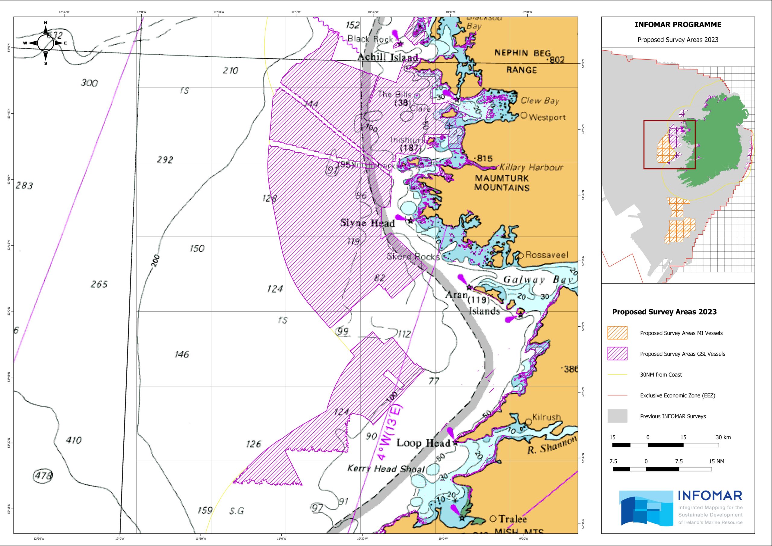
During the current year of the second phase of INFOMAR (2016-2026), operations are planned to take place within the bays, harbours, and offshore areas in the Celtic Sea, Atlantic Ocean, western coastal areas, and Irish Sea areas between March 2023 and November 2023, subject to weather and operational constraints.
Besides the navigatiional hazards this will pose, what is of importance for us is that Aeodon Coffey (new member) has found a way to translate this information into a usable format. This is now finding its way into the next edition of our Sailing Directions!
The INFOMAR Programme (Integrated Mapping for the Sustainable Development of Ireland’s Marine Resource) is a jointly managed seabed mapping initiative between Geological Survey Ireland (GSI) and the Marine Institute, funded by the Department of the Environment, Climate and Communications Covering some 125,000 square kilometres of underwater territory, INFOMAR will produce integrated mapping products covering the physical, chemical, and biological features of the seabed. Expanding upon its operational predecessor, the Irish National Seabed Survey, it has a focus on three sub-programme areas.
Survey Areas
In the Atlantic Ocean, west of counties Kerry, Clare, Galway, and Mayo.
In the Celtic Sea, southwest of Ireland.
In the the Irish Sea adjacent to the Ireland/UK border from east of County Dublin to east of County Wexford and in coastal areas of County Dublin.
In addition, inshore survey operations will potentially take place anywhere along the coast between NW County Mayo and Malin Head, County Donegal.
Additional Information
INFOMAR Charts and information on a bay basis can be found on the website http://www.infomar.ie. Images, Bathymetry, Backscatter, Shaded Relief, Classification .pdfs are available.
INFOMAR offshore & Geological Survey Ireland onshore digital data can be downloaded via https://jetstream.gsi.ie/iwdds/index.html.